Sarisalltik Trail — A Picturesque Mountain Route above Kruja
The Sarisalltik Trail is a mountain route near Kruja leading to the Bektashi tekke.
Kruja has its “hidden gems” unknown to most foreign tourists. The mountain trail above Kruja is one of these “gems.”
The trail leads to a Bektashi “holy site” at the mountain’s summit.
History of Sarisalltik
Legends and Facts About the Tekke
Sarisalltik is the name of a Bektashi religious figure who arrived in Albania around 1263. In 1325, Saint Sarisalltik visited a cave on Mount Kruja.
Today, a Bektashi tekke named after Saint Sarisalltik operates at the mountain’s summit.
Bektashi pilgrims historically ascended this mountain trail from Kruja to the peak. Thanks to their efforts, the trail has been preserved in good condition to this day.
The trail is called the “Sarisalltik Trail.” It ascends the mountain slope to the Bektashi tekke at the summit.
In the mid-14th century, during a period of rapid Bektashi expansion in Albania, the great Skanderbeg (according to legend) also used this trail to reach the summit.
Thus, the trail has been known since ancient times.
Where Is the Sarisalltik Trail Located
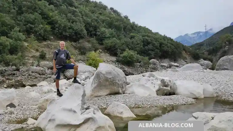
The Sarisalltik Trail begins at a road leading from the town of Kruja into the mountains toward the Bektashi tekke.
This article provides a detailed review of the trail’s starting point, the mountain hike itself, and the return journey.

- Near the sharp turn there is a sign directing you to the trail and restaurant.
Road Sign: Beginning of the Sarisalltik Trail
A signpost by the road has an arrow indicating the direction of the trail.
Turn coordinates near the staircase: 41.514908, 19.794025

- Main entrance to the trail to Sarisalltik.
Alternative Trailhead for an Easier Ascent
However, if you continue along the road for about 100 meters, you will find a gentler entry point to the trail.
It passes by a bunker, hidden as usual at a road junction.
Thus, this starting point is preferable to the direction indicated by the roadside sign.
Why is the first option less favorable?
- You will have to walk alongside a fence, behind which dogs bark and run.
- You will ascend a steep hill, pushing through weeds along a wall.
- You will become more fatigued and frustrated at the very start of the journey.
The second option avoids these three disadvantages, but increases the distance by about 200 meters.
This way, you can start the trail 100 meters from the sign, turning onto the trail near a sharp bend in the road.
The bunker will confirm that you are on the right route.
Now you have all the information you need to make an informed decision.

- Alternative start of the route along a dirt road.
Dirt Road: Route Features
You must walk straight along a level (no incline) dirt road without turning off.
Here are the coordinates for the distant turn onto a secondary road: 41.515713, 19.793413
In total, there are three possible routes to ascend:
- The first, following the road sign, is more difficult.
- The second, a steeper intermediate route, leads to a fan of road junctions.
- The third, a gentler route with a bunker near the blue bus stop, is easier and more comfortable.
The Ascent
Easy Route Along the Slope
How do you find the easy route along the slope?
Once you pass the private houses, you will come across a stone embankment.
This marks the start of the trail and presents your first challenge.
The embankment stretches high up, approximately 200 meters uphill.
You should turn left at the very beginning after walking about 30 meters along the embankment.
A valuable tip: It is crucial to turn left here to follow the well-maintained trail with steps.
Steps on the Trail: Convenience and Safety
Someone put in a tremendous effort, carrying gravel to the trail and laying stones to form steps (or something resembling steps).
In any case, the steps make the hike much easier.
I accidentally stumbled upon the actual stepped trail — and was very, very pleased.
Walking solely on the embankment was difficult, as my feet “slid” on the stones along the slope.
You are luckier now: just read this article and benefit from existing knowledge of the trail.

- The mountain path is paved with stones in the form of steps.
Landmark Along the Route: Well with a Hatch
At the start of the trail, near the path, there is a well with a hatch and a curved pipe protruding next to it.
This can serve as a landmark indicating you are on the right path.
The well is visible from the trail — just keep an eye out.

- A well with a metal cover next to the path.
First Panoramic Point: Views of the Surroundings
The entire route consists of several stages. The Sarisalltik Trail ascends, passing various points with panoramic views of the city of Kruja.
Rest stops can be taken at these scenic points.
Typically, these points are rocky outcrops standing out from the mountain’s surface.
Second Panoramic Point: Closer to the Summit
As you ascend further, you will come across several rock formations protruding above the trail.
Those who wish can climb these rocks for a better view.
In fact, my attempt to climb one of these rocks helped me discover the “real trail” rather than continuing on the slippery embankment of loose stones.
- The trail runs along rocks and cliffs.
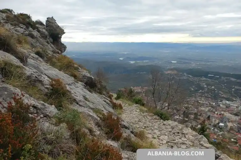
Views of Kruja from the Sarisalltik Mountain Trail
From any point on the trail, you get a stunning view of the city of Kruja and the fortress below.
Recommendation: Look around and appreciate nature. Stop frequently and take unforgettable photos as souvenirs.
After all, this is why you came here.
What the Trail Looks Like: What to Expect
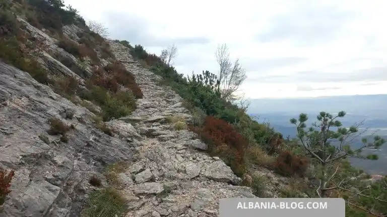
The Sarisalltik mountain trail is mostly rocky, with a base of stones or rock formations.
In some places, it is covered with small stones and gravel. It is evident that someone deliberately laid the path with flat stones.
One thing is clear — the trail has been maintained: it has been leveled, steps have been built, gravel and sand have been transported, and the surface has been compacted.
What the Sarisalltik Trail is Like
Sharp Turns: Trail Difficulty
The trail zigzags sharply, making each turn at an acute angle in the opposite direction.
You need to get used to this, as the slope is quite steep.
The average incline of the slope is about 45-50 degrees.
You are fully responsible for yourself and your behavior.
The complete freedom to “be here and now and make your own decisions” creates an indescribable sense of pride in yourself.

- The mountain trail makes sharp turns along the slope.
No Railings: What to Watch Out For
The trail sometimes runs right along the edge of a cliff and sometimes follows a relatively safe, gentle slope.
There are no railings anywhere along the trail.
The great variety of the terrain evokes different emotions in different people.
The beauty of a mountain trail is precisely this: it “awakens you from hibernation” and makes you see the world in a new way.

- There are many bushes and trees near the trail.
Trail Width
The width of the trail varies: on average, it is 1 meter wide.
Sometimes the trail expands to 1.5 meters, while in other places, it narrows to 0.5 meters. It often runs along a sheer cliff or precipice.
At times, the trail becomes smooth and “paved,” appearing well-maintained and tidy.
However, in some areas, the trail becomes “wild” and eroded by nature. There are no stairs or steps in these sections, just a general direction to follow.
What Awaits at Higher Altitudes: Mountain Risks
The higher you climb, the colder the air becomes (temperature drops).
The atmosphere at higher altitudes is thinner — oxygen levels decrease, making uphill climbing more difficult. Personally, I found myself tiring and stopping to rest more often.
For reference, the mountain’s height is about 1,100 meters above sea level.
The higher I climbed, the greater the environmental resistance became.
Additionally, looking down became scarier, especially when the trail passed along a steep drop-off.
Advice: Stop your hike if you feel uncomfortable.
Everyone has their own altitude limit. It’s better to stop and descend in time than to put yourself and your life at risk.
High-Altitude Conditions: Sudden Weather Changes
Here’s an example from my hike.
What changes started to occur:
- Time: It was already 1:30 PM, and in winter, the sun sets around 4:00 PM (I hiked on November 26, at the end of autumn).
- A strong, sudden wind appeared, bringing clouds, and it started to darken quickly.
- The temperature dropped sharply — my breath was visible as vapor. Even though in the morning, it was 18°C and sunny in Krujë, and I was wearing a t-shirt..
- The peak became shrouded in thick fog. At the start of the trail, I could clearly see the peak, though it was far away.
- I felt very fatigued (I was carrying a backpack with unnecessary items since I decided to hike directly instead of first going to the hotel).
These five factors forced me to unexpectedly stop and start descending. I didn’t reach the summit (the final point of the trail—Sarisalltik Tekke).
A piercing wind picked up, and the peak was enveloped in dense fog. I could no longer see it, even though I was already close.
Main reason for turning back: sudden weather change.

- The weather began to deteriorate – the wind blew, clouds appeared, it became cold and dark.
Recommendations for Hiking the Trail
I recommend listening to yourself and literally “watching” the weather in the mountains. Make decisions based on the situation as it develops.
By “situation,” I mean any deviation from the initial plan or ideal conditions.
It’s better to turn back if the circumstances are clearly against you.
The goal of a weekend hike is not necessarily to reach the summit.
The real goal is to enjoy the journey and the breathtaking mountain scenery.
Unnecessary (reckless) risk is not advisable.
Mountains are unforgiving of mistakes. The Albanian mountains are no exception—they are harsh and unpredictable.
Impressions of the Hike
Overall, the hike is incredibly exciting, especially for outdoor enthusiasts.
The Sarisalltik Trail above Krujë is a perfect weekend route if you love outdoor activities and new experiences.
At times, the height and sense of freedom will take your breath away.
Panoramic views, incredible vastness, fresh air, and physical activity provide an excellent cardio workout.
They also help relax the nervous system and recover from everyday stress.

- At this point the trail narrowed due to pine trees and bushes.
Tips for a Comfortable Hike
Here are my tips:
- Don’t carry unnecessary items — travel light (bring only the essentials).
- Start your hike in the morning in warm, sunny weather (always check the weather forecast beforehand).
- Follow the stepped trail on the slope rather than the gravel path (the real trail is to the left of the gravel path).
- Stop if you reach your “altitude limit” — don’t push yourself beyond your limits.
- Immediately turn back and descend if the weather changes suddenly.
In summary, the key warning is: observe the situation as it is and be ready to change your decision quickly if needed.
Keep in mind: descending takes three times less time than ascending.
For example, if you climb for 1.5 hours, the descent will take about 30 minutes (or 1/3 of the ascent time).
Important note: the ascent is quite challenging for untrained individuals. There are many steps on the trail, and some are quite high—after 1-2 hours, your legs will be tired, and your muscles will ache.
This route is just a selection of Albanian city walks. To find other trails near major cities, visit the Hiking Trails in Albania — Walking Routes and Scenic Paths section.
Shorts: Sarisalltik Mountain Trail above Kruja
Shot date: November 26, 2024.
The video features a panoramic view of the town of Kruja, Albania, taken from the trail. You can see the rugged cliffs, the rocky trail, and the panoramic view of Kruja from above.
Subscribe to the Life in Albania channel and like it – price reviews and up-to-date information about life in Albania.
Author content.
If this article helped you, you can support the author with a coffee.